
Some of you may have already seen this topic on TRF or the forums on RP, but I wanted to get this out to more people:
A thread on altimeter accuracy on TRF got me doing a little more research into the effect of the ambient air temperature on altimeter readings. What I found was:
The "standard atmosphere model" used by pretty much all altimeters to convert measured delta-pressure to delta-altitude, is based on average temperature profiles for mid-latitudes over all seasons and times of day.
For Denver, the standard atmosphere predicts that the temperature should be 39F. So the standard atmosphere will represent the pressure vs. altitude pretty well for a dawn launch in March, but it could be off by 60F for a mid-afternoon launch in July.
So does air temperature affect altimeter readings? Absolutely. Cold-weather pilots are especially interested in this effect because for temperatures well below the standard atmosphere temperatures, their altimeters will read high. For them, getting this right is a matter of life and death. The Canadian Civil Aviation folks have a website ( http://www.tc.gc.ca/CivilAviation/publications/tp14371/RAC/9-1.htm#9-17-1) ) that gives a formula for the effect, and what it says is that for a hot-weather launch that is 60F warmer than the SAM, our altimeters will read low by more than 10%.
So if you had a launch on a hot afternoon that went 5500 feet when you were expecting over 6000, don't blame Rocksim's drag estimates. Blame your altimeter.
Here is some confirmation with real data taken from weather balloons recently in Denver and Grand Junction: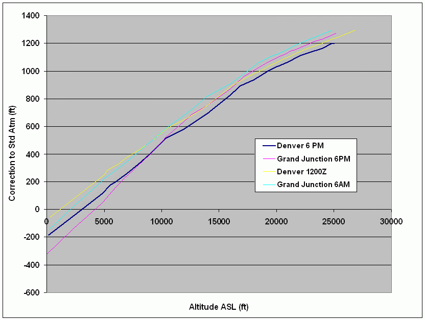
What I'm graphing here is the correction that would need to be applied to altimeter readings on Sunday June 22, based on subtracting the standard atmosphere altitudes from the measured balloon altitudes for a given pressure.
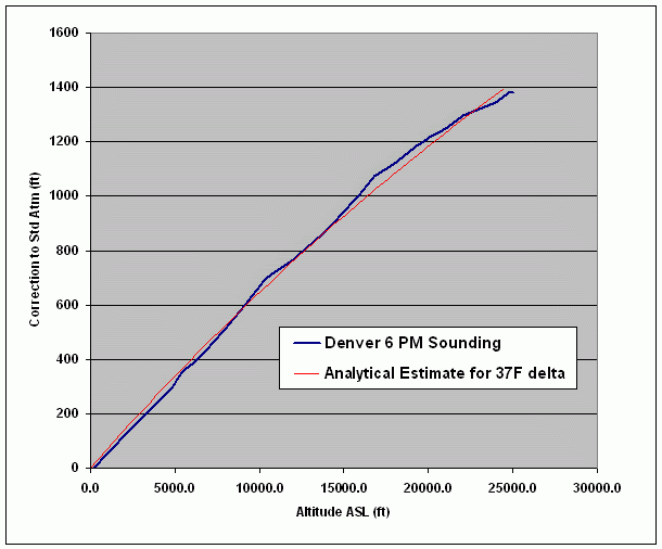
The delta-temperature for the Denver 6PM curve (which was about 37F above the standard atmosphere) is compared below to the analytical solution found in the Canadian civil aviation procedures:
I've added in this correction in the Parrot's post-flight analysis template for now, but I may need to make it optional until more people in rocketry get educated about this. In particular, the records were probably all calculated using the standard atmosphere, and may be pretty inaccurate in some cases because of that.
In the meantime, if you want to set a record using a barometric altimeter, do it on a cold day in the winter!
Interesting info, thanks for taking the time to post it, Adrian.
Very interesting... and I would say a prime motivation for adding an ambient air temperature sensor and data point along with every altitude data point. This certainly makes sense to me. I had long heard of the standard atmosphere model and knew something about how Jim Amos applied it on Missileworks altimeters - I didn't know it was fixed at such a low air temperature (I don't fly when it;s that cold usually) or that it was NOT temperature compensated for the range of likely flight temperatures.
This is definitely something to raise a stink about in the community if people are interested in precision AND accuracy in their altitudes. Another thought is what is the latency of temperature sensors - the only one I have hands on experience with is the National LM-35, probably long since superseded by newer and cooler components - it had over 10 seconds of latency when heat sinked. I would expect you either want something with true real time capability or somehow offset the temp readings based on letency when doing data reduction and analysis.
Warren
The Parrot does measure chip temperature along with every pressure measurement, but I don't recommend that for this purpose because the temperature of the board can be way off from ambient. In Chris's Cirrus Dart last summer if I recall correctly the measured temperature inside his av-bay was around 130 F, when it was about 90 outside. A temp sensor mounted in the airstream, say built into a fin, would do better, but even that would have a hard time measuring the air temperature without any effect from the sun.
What I would recommend, though, would be to at least use the ambient air temperature near the pad to calculate an offset from the standard model, and assume a constant offset throughout the flight. That's what was the assumption behind the second graph I showed. That should work well unless there's something really weird like a winter air inversion.
I think that for record attempts, the submitter should provide sounding data from the nearest balloon and provide that with the record documentation. It's really easy to get from this site: http://weather.uwyo.edu/upperair/sounding.html. Ideally, all the records should be corrected for temperature from the balloon data. I wonder how far back the UW data goes?
By the way, the Tripoli record form does ask for ambient air temperature and pad altitude, so if they have that data from every record, then they could correct all of them, at least assuming that the temperature is just off by a constant throughout the profile.
Oh, and my updated best estimate for the true altitude of my F shot on the 22nd was 7904 🙂
Some of you may have already seen this topic on TRF or the forums on RP, but I wanted to get this out to more people:
A thread on altimeter accuracy on TRF got me doing a little more research into the effect of the ambient air temperature on altimeter readings. What I found was:
The "standard atmosphere model" used by pretty much all altimeters to convert measured delta-pressure to delta-altitude, is based on average temperature profiles for mid-latitudes over all seasons and times of day.
For Denver, the standard atmosphere predicts that the temperature should be 39F. So the standard atmosphere will represent the pressure vs. altitude pretty well for a dawn launch in March, but it could be off by 60F for a mid-afternoon launch in July.
So does air temperature affect altimeter readings? Absolutely. Cold-weather pilots are especially interested in this effect because for temperatures well below the standard atmosphere temperatures, their altimeters will read high. For them, getting this right is a matter of life and death. The Canadian Civil Aviation folks have a website ( http://www.tc.gc.ca/CivilAviation/publications/tp14371/RAC/9-1.htm#9-17-1) ) that gives a formula for the effect, and what it says is that for a hot-weather launch that is 60F warmer than the SAM, our altimeters will read low by more than 10%.
OK Soooo
You guys just remember to add " 10% " to my SSSS next Saterday.
Sounds fair to me. 🙂
Scott,
Isn't that like the Bob and Doub Mackenzie metric conversion gig????
So Adrian, what is going to be the best way for us to correct for this effect? Should we have an altimeter calibration sigh at each launch or what? It seems to me that if someone is taking it upon themselves to recalculate their altitude we could have some erroneous numbers or questionable altitudes being reported. You know what I mean? Basically a standardized formula or value....
Anyone? Anyone? Beuhler, Beuhler
At the risk of being shot for posting a bunch of gibberish, here goes.
+++++++++++++++++++++++++++++++++++++++++++++++
9.17.1 Corrections for Temperature
The calculated minimum safe altitudes must be adjusted when the ambient temperature on the surface is much lower than that predicted by the standard atmosphere. In such conditions, an approximate correction is four percent height increase for every 10˚C below standard temperature, as measured at the altimeter setting source. This is safe for all altimeter setting source altitudes for temperatures above -15˚C.
For colder temperatures, a more accurate correction should be obtained from the “Altitude Correction Chart” in the General Pages of CAP (which is reproduced in RAC Figure 9.1). This table is calculated for an aerodrome at sea level. It is, therefore, conservative when applied to aerodromes at higher altitudes. To calculate the reduced corrections for specific aerodrome or altimeter setting sources above sea level, or for values not tabulated, see the paragraphs below.
The “Altitude Correction Chart” was calculated assuming a linear variation of temperature with height. It is based on the following equation, which may be used with the appropriate value of to, H, Lo and Hss to calculate temperature corrections for specific conditions. This equation produces results that are within five percent of the accurate correction for altimeter setting sources up to 10 000 ft and with minimum heights up to 5 000 ft above that source.
Correction = H * ((15-t0)/(273 + t0 - 0.5 * Lo * (H + Hss)))
where:
H = minimum height above the altimeter setting source
(the setting source is normally the aerodrome, unless otherwise specified)
to = taerodrome + Lo * haerodrome aerodrome (or specified
temperature reporting point) temperature adjusted to sea level
Lo = 0.0065˚C per metre or 0.00198˚C per foot
Hss = altimeter setting source elevation
taerodrome = aerodrome (or specified temperature reporting
point) temperature
haerodrome = aerodrome (or specified temperature
reporting point) elevation
For occasions when a more accurate temperature correction is required, this may be obtained from the following formula, which assumes an off-standard atmosphere.
∆hCORRECTION = ∆hPaircraft -∆hGaircraft = (-∆Tstd/Lo) ln[1+Lo.∆hPaircraft
/ (To + Lo.hPaerodrome)]
where:
∆hPaircraft = aircraft height above aerodrome (pressure)
∆hGaircraft = aircraft height above aerodrome (geopotential)
∆Tstd = temperature deviation from the ISA temperature
Lo = standard temperature lapse rate with pressure
altitude in the first layer (sea level to tropopause)
of the ISA.
To = standard temperature at sea level
The above equation cannot be solved directly in terms of ∆hGaircraft, and an iterative solution is required. This can be done with a simple computer or spreadsheet program.
NOTE: Geopotential height includes a correction to account for the variation of g (average 9.8067 m sec2) with height. However, the effect is negligible at the minimum altitudes considered for obstacle clearance: the difference between geometric height and geopotential height increases from zero at mean sea level to –59 ft at 36 000 ft
Both the above equations assume a constant off-standard temperature lapse rate. The actual lapse rate may vary considerably from the assumed standard, depending on latitude and time of year. However, the corrections derived from the linear approximation can be taken as a satisfactory estimate for general application at levels up to 12 000 ft. The correction from the accurate calculation is valid up to 36 000 ft.
As a matter of club policy, the only acceptable altitudes reported for club record purposes is the direct, unmodified and unprocessed output of a stock, unmodified commercially available altimeter utilizing a barometric sensor (no accelerometer based altimeters) that has also been approved by Tripoli for use in Tripoli world altitude records.
1 - no post processing of data
2 - no modification from the factory standard delivered unit
3 - results must be repeatable with any arbitrary example of the same brand and model altimeter.
If we are to be serious about temperature compensation (I believe we should be) then the only solution is to lobby manufacturers to perform this on board their altimeters and provide a direct reading of the processed altitude.
Warren
Adrian,
Very cool work on the Parrot as well as all your work on the minimum diameter shots.
I've missed a bunch of threads and pardon me if you've answered this already - but is the key element of difference in the temperature compenstion based on the US SAM -6.5c/KM assumed temperature difference in the first 10 Km ASL versus actual temperature.
So, is the Parrot's post-processing recalculating the degrees/KM or is it just recalculating the base altitude?
Ed
Hello,
So would the temperature explain the difference in the data recorded from my most recent flight? There is a 1500 foot difference between the accelerometer and the baro reading. I thought that it was caused from the baro not being calibrated to 4000 ft but now I realize it could have been the temperature. It was close to 90 degrees outside and inside of the foil lined av-bay probably much higher. However is this enough to cause almost a 20% decrease from the acc reading? How can I determine the max altitude achieved?
Thanks a bunch, can't wait to fly with you guys again soon!
Steve H.
The graph is hard to read but the blue line is the acc (7965 ft.) and the black is the baro (6513 ft.)

I've missed a bunch of threads and pardon me if you've answered this already - but is the key element of difference in the temperature compenstion based on the US SAM -6.5c/KM assumed temperature difference in the first 10 Km ASL versus actual temperature.
So, is the Parrot's post-processing recalculating the degrees/KM or is it just recalculating the base altitude?
If I understand your question correctly, the correction factor I'm talking about is caused by a constant temperature offset compared to the SAM assumptions, while still assuming the same temperature lapse rate of -6.5c/Km. So while the SAM assumes a temperature of 39F at 5400 feet and -6.5C/km as you go up from there, the proposed correction would start with a temperature equal to the ambient air temperature at 5400 feet, decreasing at -6.5 C/km from there.
So would the temperature explain the difference in the data recorded from my most recent flight? There is a 1500 foot difference between the accelerometer and the baro reading. I thought that it was caused from the baro not being calibrated to 4000 ft but now I realize it could have been the temperature. It was close to 90 degrees outside and inside of the foil lined av-bay probably much higher. However is this enough to cause almost a 20% decrease from the acc reading? How can I determine the max altitude achieved?
The difference is probably caused by a combination of the temperature effect I'm bringing up, and non-vertical flight caused by weathercocking, and possible calibration errors.
The black rock desert is at 3848 feet, according to Wikipedia, so the standard atmosphere temperature is 45 degrees F. The ambient air temperature at the launch site is 90 F (the internal av-bay temperature doesn't matter if your altimeter reads pressure correctly at high temperature), so the delta from the standard atmosphere temperature is 45F. I'll calculate that out a little later, but it should be somewhere around 7-8%.
That leaves about 12-13% that could be caused by a combination of calibration errors and weathercocking.
I love it when it gets to the gibberish level of geek. I fly, therefore, it is what the altimeter tells me.
I love it when it gets to the gibberish level of geek. I fly, therefore, it is what the altimeter tells me.
You and me both!!! I'm a Geologist. Talk rocks and oil and I can keep up.
When life hands you lemons, make lemonade. And when your wife hands you a sandwich baggie full of mint harvested from an overgrown AeroGarden, made mojitos. But don't expect to be able to write clearly on a techical topic afterwards. 8)
When life hands you lemons, make lemonade. And when your wife hands you a sandwich baggie full of mint harvested from an overgrown AeroGarden, made mojitos. But don't expect to be able to write clearly on a techical topic afterwards. 8)
Hold on there Adrian. You sure that wasn't something else that was harvested and tossed over the fence into your Aero Garden??? Did you have an intense feeling that you needed to watch a Cheech-n-Chong movie while munching on Pizza?????
So, I take it this has run it's course now that Warren has wrangled us in??? Nothing left to do but remember the old days when we sat around the computer talking about altimeter temperature something or another 😆
Latest Post: Hello World Our newest member: lawrencebmu435 Recent Posts Unread Posts
