
Hey everyone,
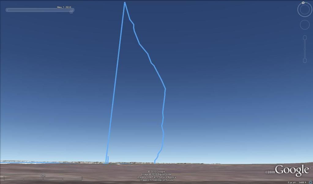
Here is the tracking information on Little Blue Dawg. It starts out on line 250 as a reference. On line 256 motor lites. Line 258 were gone. Raven had a reading of 7401' @ 554MPH which i think is very accurate to the DC30, if you look at lines 274,275, and 276 you see the MPH is pretty even, with height of 7467', 66' thats darn close. GPS didn't stand a chance during the thurst.
250 4/10/2010 202 PM 5398 ft 0 ft 005 0 mph 0° true N40 53.180 W104 38.283
251 4/10/2010 207 PM 5398 ft 0 ft 005 0 mph 0° true N40 53.180 W104 38.283
252 4/10/2010 212 PM 5398 ft 4 ft 015 0.2 mph 180° true N40 53.180 W104 38.283
253 4/10/2010 227 PM 5402 ft 1 ft 005 0.2 mph 270° true N40 53.179 W104 38.283
254 4/10/2010 232 PM 5403 ft 3 ft 030 0.1 mph 270° true N40 53.179 W104 38.283
255 4/10/2010 202 PM 5400 ft 0 ft 005 0 mph 0° true N40 53.179 W104 38.284
256 4/10/2010 207 PM 5400 ft 48 ft 025 1.3 mph 348° true N40 53.179 W104 38.284
257 4/10/2010 232 PM 5406 ft 0.5 mi 015 108 mph 170° true N40 53.187 W104 38.286
258 4/10/2010 247 PM 13102 ft 373 ft 020 13 mph 53° true N40 52.802 W104 38.195
259 4/10/2010 207 PM 12334 ft 201 ft 010 14 mph 86° true N40 52.839 W104 38.130
260 4/10/2010 217 PM 12093 ft 71 ft 005 10 mph 7° true N40 52.842 W104 38.086
261 4/10/2010 222 PM 11970 ft 122 ft 005 17 mph 26° true N40 52.853 W104 38.084
262 4/10/2010 227 PM 11845 ft 407 ft 020 14 mph 50° true N40 52.871 W104 38.073
263 4/10/2010 247 PM 11312 ft 420 ft 020 14 mph 94° true N40 52.914 W104 38.005
264 4/10/2010 207 PM 10811 ft 166 ft 010 11 mph 57° true N40 52.910 W104 37.914
265 4/10/2010 217 PM 10547 ft 101 ft 005 14 mph 49° true N40 52.925 W104 37.884
266 4/10/2010 222 PM 10408 ft 146 ft 005 20 mph 85° true N40 52.936 W104 37.867
267 4/10/2010 227 PM 10279 ft 472 ft 025 13 mph 66° true N40 52.938 W104 37.836
268 4/10/2010 252 PM 9629 ft 452 ft 015 21 mph 41° true N40 52.969 W104 37.742
269 4/10/2010 207 PM 9281 ft 125 ft 010 9 mph 0° true N40 53.025 W104 37.678
270 4/10/2010 217 PM 9079 ft 25 ft 005 3 mph 21° true N40 53.046 W104 37.678
271 4/10/2010 222 PM 8981 ft 0.2 mi 030 19 mph 7° true N40 53.050 W104 37.676
272 4/10/2010 252 PM 8234 ft 201 ft 010 14 mph 23° true N40 53.185 W104 37.654
273 4/10/2010 202 PM 7985 ft 236 ft 010 16 mph 4° true N40 53.216 W104 37.637
274 4/10/2010 212 PM 7729 ft 75 ft 005 10 mph 340° true N40 53.254 W104 37.633
275 4/10/2010 217 PM 7595 ft 66 ft 005 9 mph 44° true N40 53.266 W104 37.639
276 4/10/2010 222 PM 7467 ft 104 ft 010 7 mph 58° true N40 53.274 W104 37.629
277 4/10/2010 232 PM 7195 ft 397 ft 025 11 mph 4° true N40 53.283 W104 37.610
278 4/10/2010 257 PM 6583 ft 216 ft 010 15 mph 358° true N40 53.348 W104 37.603
279 4/10/2010 207 PM 6346 ft 278 ft 010 19 mph 333° true N40 53.383 W104 37.604
280 4/10/2010 217 PM 6119 ft 159 ft 005 22 mph 9° true N40 53.424 W104 37.632
281 4/10/2010 222 PM 6002 ft 104 ft 005 14 mph 335° true N40 53.449 W104 37.627
282 4/10/2010 227 PM 5887 ft 172 ft 005 24 mph 332° true N40 53.465 W104 37.637
283 4/10/2010 232 PM 5769 ft 205 ft 010 14 mph 17° true N40 53.490 W104 37.654
284 4/10/2010 242 PM 5528 ft 139 ft 130 0.0 mph 339° true N40 53.522 W104 37.641
Hi David,
Looking at that log, I'd say your apogee is on line 258 at 13102. If you subtract out ground elevation of 5400, you get an AGL of 7702. Still in the same neighborhood as the Raven, but a bit more than 66' difference. Mighty nice flight all the same.
Play with it some more - you should be able to upload the track from the DC-30 through the Astro to Google Earth.
Hello,
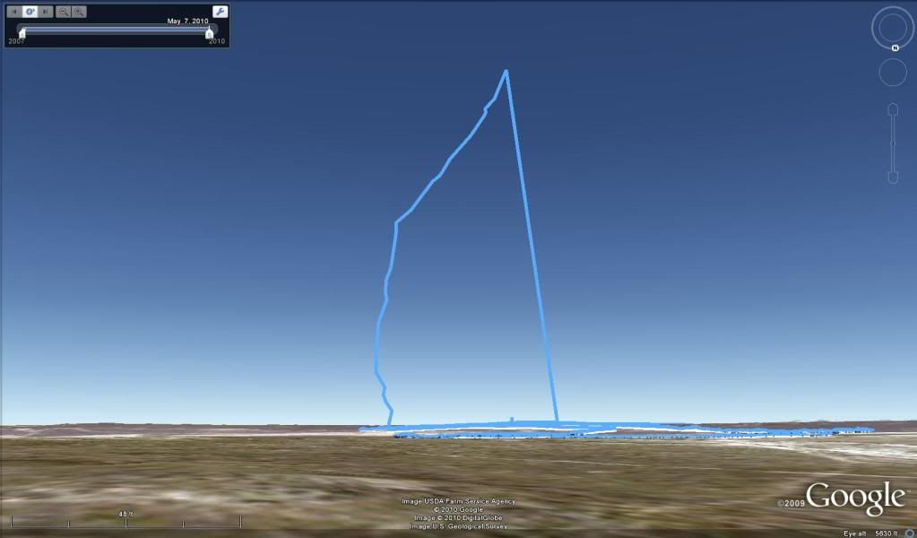
I figured it out Ken, thanks. Here is the GPS track photo.
very nice
that is a fantastic plot! If its not too much trouble can you post instructions on how you accomplished the download from the dc30 to google earth? I have a dc-20 and would love to do the same thing but I am not the most computer literate! all help is appreciated! thanks, Sean
that is a fantastic plot! If its not too much trouble can you post instructions on how you accomplished the download from the dc30 to google earth? I have a dc-20 and would love to do the same thing but I am not the most computer literate! all help is appreciated! thanks, Sean
You should be able to plug your GPS (the handheld unit) in to the computer with a USB cable. Then, you can open Google Earth, go to "Tools" menu, then "GPS". Select "Garmin", then download. There should be an option to not pin the altitudes to ground level (otherwise you'll just get a groundtrack).
Got to figure out how to do that.
Need to figure out how to store tracks for later download too.
The more I play with my DC-30 and Astro, the more I like it.
Thanks, I'm looking forward to trying that out after MHM. I too love the Garmin system - I just picked up another DC-20 for $90 off the ebay site Wilke referenced - brand new - arrived 3 days after the order. -Sean
Go to www.gps4us.com
They sell new DC-20 for $91.99 and free delivery, if you do regular shipping.
I bought a DC-30 from these guys. Got it in a few days. They accept MC/VISA and PayPal too.
Look under the outdoor tab, dog tracking.
My astro was set to record on default settings. Sean, If you have ever tracked with your astro there is prolly a track you can look at.
First trip out Asto recorded 756 points, takeing up only 17% in the "built in" memory storage.
So what is the smallest nose cone anyone has put a DC 20 into? was it a 38mm cirus dart? so many post
Thanks
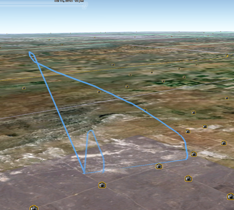
Hi everyone,
Here is a veiw of the track from the opposite direction.
My astro was set to record on default settings. Sean, If you have ever tracked with your astro there is prolly a track you can look at.
First trip out Asto recorded 756 points, takeing up only 17% in the "built in" memory storage.
So what is the smallest nose cone anyone has put a DC 20 into? was it a 38mm cirus dart? so many post
Thanks
I have one fit in a dart. Drilled a hole in the nose cone to recieve the antenna and still get in an altimeter. H and I shot. 8)
Hey Guys,
Here is a google earth comparsion, 2 tracks, lower track=7,401'. High track= 10,868'. Altitudes are from Raven, GPS on this last flight was 400 feet higher. Wish I could share some of the graphs from the Raven with you guys, they are Super Kool. I can't seem to figure out how to export them. (Hint, Hint, Hi Adrian)
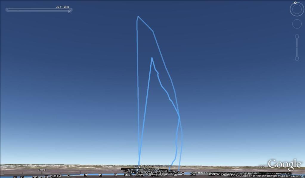
Very cool - is that from last weekend?
Here's my track from my M1939 shot to 17,880 on Sunday morning - it gives a very good track of wind at all altitudes, since the descent rate was pretty much constant the whole way down (thanks to my dumping the main at apogee). It's interesting to see how calm it was in the bottom 4000 feet or so, compared to the wind up high (oh, and the lower track was a flight by Richard and Kaleb Fonzi later in the day, on a longburn K motor).
Chris - you never gave me the data file you uploaded from my DC20 for my L3 (many thanks for your assistance by the way). I've been wondering what my flight looked like so would love to get the data file if you still have it.
Warren
Latest Post: Hello World Our newest member: everettelist43 Recent Posts Unread Posts
