

What appeared to be a succesful flight of my two-stage rocket came back without the fin can (and 54mm motor) from the sustainer stage. The 1/4" Kevlar broke at the knotted loop for the drogue chute attachment. Rock sim says that the fin can would not have been stable (-8.63) in that configuration, Deployment occured about 3/4 of a mile away due west of the launch site. Ian and I walked a beeline path from the GPS trajectory out to 2.2 miles with no luck. Becky and I search a bit south of the trajectory for 1 mile, no joy. Its possible it may have tumbled to the north side of the track. Tim's going to hold off charging me for the hardware until all hope is lost. The fin can section also contains an avbay MW timer. Its g10 FG (unpainted) with black carbon-fibered fins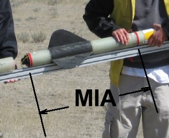
Full Size 
I've now entered the society of lost rocket parts. I was real lucky prior to this. 😀
Jeremiah and I were parked on the northern end when it flew. We watched it fall till it went over the hill. From our angle, it looked like it went down just over the hill to the west of the trail and road "T" possibly on the south side of the trail (at least I think that was a trail). I can't explain it very well, but, I will be meeting up with a guy in Ft. Collins on Saturday and will try and drive back over there and look. I'll grab my kids have them to do some walking with me. What color is it?
Jeremiah and I were parked on the northern end when it flew. We watched it fall till it went over the hill. From our angle, it looked like it went down just over the hill to the west of the trail and road "T" possibly on the south side of the trail (at least I think that was a trail). I can't explain it very well, but, I will be meeting up with a guy in Ft. Collins on Saturday and will try and drive back over there and look. I'll grab my kids have them to do some walking with me. What color is it?
Man, that would be great. I never saw that part of it. I put the picture (courtesy of Mike S's posting) on the previous note). The worst part of not having a perfect flight is not having the pieces to do a thourogh post-mortem to make sure it doesn't repeat in the future. Here's a download of the GPS with a 268 degree radial put. We looked further south on the white dotted lines.
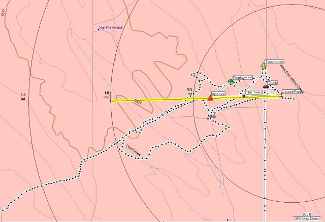
Fullsize PDF: http://www.telerover.com/rockets/MS/TheTwinsTrack4.pdf
I am trying to contact Performance Rocketry to get some more parts to make that section again, to try again
Assuming N is the launch pad. My best estimate of landing zone would have been S/2 NW of 27 to the N/2 SW of 27. Or, using strike, I would say between 285 and 300*. I'm betting close to the center of sec 27 to the section line with 28. The map is really helpful. I will print a copy to take with me as well as a Delorme copy.
Update on the trip up. We are leaving out Sat am about 5:00 and heading straight there. Jeremiah may be with me as well, I'm taking some young eyes with me too. Cross your fingers.....
Greg
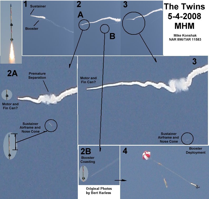
Bert sent me some high resolution pictures whiuch I was able to zoom in on and get some revealing information, Thanks Bert! It appears the boost section of the sustainer was aerodynamic for a while after it came apart from the rest of the sustainer. Now I know why the altimeter(s) read so low.
Update on the trip up. We are leaving out Sat am about 5:00 and heading straight there. Jeremiah may be with me as well, I'm taking some young eyes with me too. Cross your fingers.....
Greg
Greg, Thank you again for doing this. Check out the new photos -- the boost section was under power for a bit so it may be out past a mile. My cell phone is 303-921-8709.
How far into the flight did the Sustainer motor ignite and how long would it have gone for after the separation?
It looked like to me that after it coasted a bit, it started falling flat and spinning. I think it went further to the west than I was first thinking. The angle we were at would put it closer to NW-NE/4 of Section 28 not 27.
Ain't hi-res digital photography great for failure analysis?!
Looks like you need bigger shear pins into a longer coupler??? That or a one-piece sustainer with all-out-the-top dual deployment (tethered main).
Cool flight nonetheless! 8)
Ken
That has to be the most Challenger-like post mortem video I've ever seen in rocketry. Excellent Mike.
Warren
Most excellent analysis Mike. I would go up and help look but its Mothers Day weekend. 😉 It would be way out there, past where some one would happen apon it. Perhaps 5 or 6 of us at next launch could look.
You should kick in those engineering calcs, for burn time and speed and distance traveled of that section. 8)
Right about now I'll bet you wish it was painted my Mono Tone Blaze Orange, huh. 😉
How far into the flight did the Sustainer motor ignite and how long would it have gone for after the separation?
It looked like to me that after it coasted a bit, it started falling flat and spinning. I think it went further to the west than I was first thinking. The angle we were at would put it closer to NW-NE/4 of Section 28 not 27.
Greg, I downloaded the GPS info. Here's the tracks, the last has a 2 mile line extended on the original. The white track is where I walked with the handheld. It appears I misread the vector out on the range and walked in a line created by the falling sustainer before main deployment. Ian and I walked about 20 degrees too far south. We walked 2.2 miles out then got picked up by Becky (the cell phone was working) in the truck who took us back on the road.
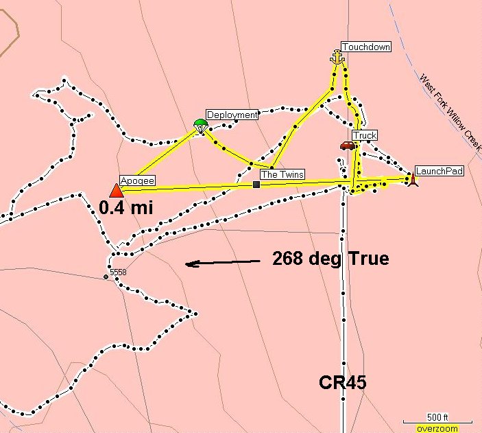
Fullsize PDF: http://www.telerover.com/rockets/MS/TheTwinsTrack.pdf
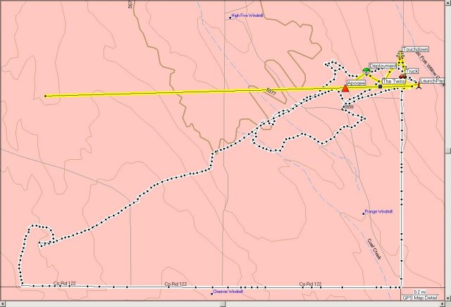
Fullsize PDF: http://www.telerover.com/rockets/MS/TheTwinsTrack3.pdf
The apogee mark (of the Dc20), which is actually the separation point, is at N40 53.158 W104 38.696 0.4 miles from the pad, however the pictures show that the MIA part continues up and way. The Ground Speed from launch to the apogee mark was 144 mph. Assuming that The real apogee was at 0.5 mi, then the MIA fin can should be about twice that distance or 1 mile away, about the distance to the High Five Windmill. But... if the fin can stayed aerodynamic, it may be further, a lot further.
Fullsize PDF: http://www.telerover.com/rockets/MS/TheTwinsTrack4.pdf
Thanks for the maps, those will really help. I love the technology we have to use now, it makes things so much easier. The pictures are outstanding, talk about pinpoint accuracy - WOW.
My plan of attack is to get on top of the little ridge with a high power spotting scope and do a thorough coverage of the area first. The vegetation is low enough that at that angle I should be able to see a lot on the ground. I can do a go-to track on my gps to look at anything that sticks out. I love stuff like this, the challenge is like a couple mugs of coffee.
I'm hoping I com across some other free ranging birds too, who knows....
Greg
Remember that it may have "lawn darted," so you may not see it clearly enough. Mike, if you could just provide a little more information... Ha! You are so cool. 😉
Remember that it may have "lawn darted," so you may not see it clearly enough. Mike, if you could just provide a little more information... Ha! You are so cool. 😉
I don't think it did, I saw it flat rolling for a bit. But, who knows what really happened.... My eyes aren't always the best, that's why I'm taking my old friend Bariska with me 😛
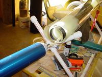
Mike's info reads like that new Apogee newsletter, only more of it. The pictures of the loading process are just amazing.
G
Mike's info reads like that new Apogee newsletter, only more of it. The pictures of the loading process are just amazing.
That's why Mike has 25 patents, 11 pending. I was standing with him, and I never saw it fall... just the fact that it was gone when I recovered the sustainer. Listen, good luck in finding it. Mike, see what kind of club this is?
Latest Post: Hello World Our newest member: jungferreira Recent Posts Unread Posts
