
Greg, You are too cool to want to do this. I'm going to try and get up there and join you. What time will you be there? Can you give me your cell phone #
Mines 303-921-8709
[FYI, Bruce, That's 26 Patents now, 11 pending - I'm going to have to adopt you 8) The title of the my latest submission is "Thermal Transfer Technique using Heat Pipes with Integral Rack Rails". ]
I am going to try and get up at 4am and be there around 6:30.
I have a long day and wanted to spend a couple of hours up there at least, possibly more if I'm having a good time wondering around the place.....
FYI, I'm going to try two methods. One will be take a heading off the spot where I was standing while watching and the other is a heading from the approximate separation point. It appears to me there is a small "U" shaped ridge line trending NW/SE w/ the opening to the NW. If I can get to a high enough point with the spotting scope, I'm hoping to better my chances.
PS, I'm a Geologist plus find search and recovery missions to be of the best fun. So, that being said, this is a serious but extremely fun outing for me and you don't have to feel obliged to come up. BUT, four or more eyes are better than my two+1. 😛
My cell is 303-916-7051 I drive a charcoal Grey, Dodge 4x4 truck.
Greg
Well,
I'm a bit embarrassed and bummed as well. I was not aware that the fence at about 1 mile to the west of the launch site is not a private property boundary. So, I did not cross it. My GPS tells me that I did manage to cover about 6 miles on the west side and 1.5 miles on the East side. Lots of walking for 3 hrs of time. I did cover the area roughly 200 yards south of the flight line up to and past the fence to the north. I did get to look at that valley to the west of the fence, but did not see it. The spotting scope was a big help. I managed to see a 12" orange shute back on the east side of the road about 1.5 miles away.
If someone has a map showing the private boundaries it would help.
Greg
Greg, I know Mike apreciates it very much. He posted a map of what is and is not private property elsewhere on the site. I think it is under "Raunchers" something or other. Really good of you to do this. You are definitely a new and valued member. 😉
Thanks,
I enjoy being out doors and wondering aimlessly 😛 So it was fun for that part of it. I'll find the map for future trips. It's hard being up there for the first time, in retrospect, I should have checked the lines first.
Fin Can Found on the Desolate Prairie! Another Pawnee Death

I took advantage of Sunday, because I didn't have any rockets to launch, to look for my errant fin can off "The Twins" sustainer. Since I had numerous reports of searches that were up to the fence (1 mile to the east) I started out by parking 3 miles to the west along CR126 and hiked north 1 mile then wandered back toward the launch site. The plan was to be about a quarter mile north of the predicted track I had extended from my DC-20 GPS real track, as there was a north easterly wind that day. Then I would walk to the real track a nd follow it straight out west. My original assumption was the the fin can would maintain its trajectory, given that the momentum would keep it heading in the direction it was going at the time of separation. Assuming it was ballistic, it would have traveled the same distance and arc on the way down that it had on the way up. So the estimated location would have been twice the distance recorded on the onboard DC20 from the launch site to apogee.
As it turns out, after walking 3 miles worrying the antelope to death, I crossed the fence just to get to the gps track. I almost didn't do it since others probably went there before, but just to be thorough I went a bit more further to the east.
Sure enough within 100 feet of the end of the predicted track, there it was! 😀 Here's where the GPS marked the spot:
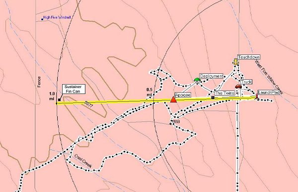
http://www.telerover.com/rockets/MS/TheTwinsTrack5.pdf
This was another great example of having a Dc20 onboard to help locate your rocket, or in this case, rocket parts. Unfortunately, I was now the furthest away from the truck, another 2-1/2 miles as crow flies, having to carry the fin can but I had a renewed vigor. I had carried a couple containers of water with me to help with the sorjourn, and I am glad I did. If the expiremental launches had not been canceled earlier in the day due to winds, I could have hiked a much easier distance back to the NCR site, and gotten a ride, but, alas they had all gone home. 😥
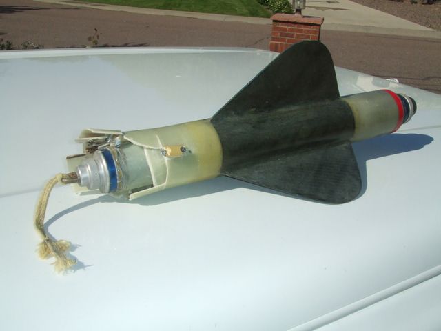
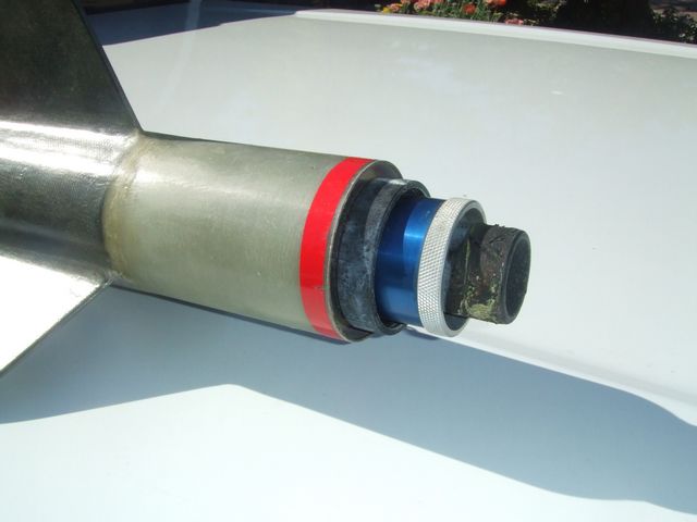
Rocksim said the fin can by itself would not have been aerodynamic, but it was obvious that it dived in the dirt nose first, shattering the airframe and kicking back about 6 feet from the hole. I picked uo all the pieces that were there. The 9V battery had even split apart! The Missile works timer was broken in half and the 10-32 all-thread studs were buckled and broken in half. The K700 motor hardware was shoved back through the retainer, popping a nice aluminum ring out of the aeropack. I pried the motor out of the fin can hoping it would still be usable, but there is nick in the end making the forward closure bind. I'll have to see if I can grip it good enough to unscrew the end and try and rework it. It looks like I'll owe Tim for the motor hardware, as I don't think anyone else will want to use it.


Thanks for all the guys who took time to help me in the search!
Very nicely done, Mike!
I can't believe it. I must have walked past it at least two times. 😳 So much for my tracking abilities..... I'm happy you found it! Bummed that I missed it....
Congrats.
... Bummed that I missed it....
ME TOO! I've got blisters on my feet. 😉
Latest Post: Hello World Our newest member: jungferreira Recent Posts Unread Posts
